NASA
Scientists Use Satellites
to Help Track and Control a Disease
 Using
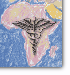
weather satellites to spot the early signs of an El Nino, NASA
and Defense scientists may be able to help save East Africans
and their livestock from Rift Valley Fever, a mosquito-borne
disease that can be fatal to humans and animals. Using
weather satellites to spot the early signs of an El Nino, NASA
and Defense scientists may be able to help save East Africans
and their livestock from Rift Valley Fever, a mosquito-borne
disease that can be fatal to humans and animals. |
| |
 HUD
Tailors Its Website for Customers and Partners HUD
Tailors Its Website for Customers and Partners
The
Department of Housing and Urban Development has created "shortcuts"
on its website to help its partners--such as academics, appraisers
and attorneys--and citizen groups--such as farmworkers, seniors,
and veterans--get the information they want. |
| |
200
Programs Help Make Livable Communities
 How
do you make your community a better place to live? This site
collects and sorts more than 200 programs and links across a
dozen federal agencies. Categories include Strengthening Local
Economies, Reclaiming Brownfields, Promoting Transportation
Choices, Securing Safe Streets, Preserving Open Space and Farmland,
and Creating Community Schools and Civic Places. How
do you make your community a better place to live? This site
collects and sorts more than 200 programs and links across a
dozen federal agencies. Categories include Strengthening Local
Economies, Reclaiming Brownfields, Promoting Transportation
Choices, Securing Safe Streets, Preserving Open Space and Farmland,
and Creating Community Schools and Civic Places. |
| |
Digital
Maps: An Idea Whose Time Had Come
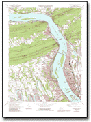 The
US Geological Survey's highly-regarded topographic "quad" maps
have been used for everything from determining a dam site to
planning a bird watching trip. It takes 55,000 maps to cover
the continental United States. It took the USGS several decades
of work to produce this many maps, finishing in 1993. They are
wonderful, but they are expensive to produce or revise. Besides,
a growing customer segment wanted digital maps they could display
on computer monitors. It took the agency less than two and a
half years to scan these maps. Now they are selling well in
a new medium--CDs, with 67 maps on each one. The disks have
a multitude of uses, including helping monitor clean-up work
in the Fargo, ND, area following the 1998 flood. The
US Geological Survey's highly-regarded topographic "quad" maps
have been used for everything from determining a dam site to
planning a bird watching trip. It takes 55,000 maps to cover
the continental United States. It took the USGS several decades
of work to produce this many maps, finishing in 1993. They are
wonderful, but they are expensive to produce or revise. Besides,
a growing customer segment wanted digital maps they could display
on computer monitors. It took the agency less than two and a
half years to scan these maps. Now they are selling well in
a new medium--CDs, with 67 maps on each one. The disks have
a multitude of uses, including helping monitor clean-up work
in the Fargo, ND, area following the 1998 flood.
|
| |
|
|
In
This Issue
Satellites
Track Disease
HUD
Site's Shortcuts
Livablle
Communities
Digital
Maps
Back
Issues
Vol.
1, No. 39, July 19, 1999
Vol.
1, No. 38, July 12, 1999
Vol.
1, No. 37, July 5, 1999
Vol.
1, No. 36, June 28, 1999
Vol.
1, No. 35, June 21, 1999
Past
Issue Archive
|
|