![]()

![]()
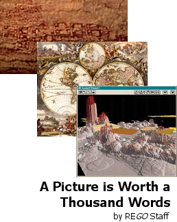
Image Information: A town map from Catal Huyuk, a renaissance map of the world, and a computer-generated map showing incidents of crime with gang "turf" in Salinas CA.
![]()
![]()
![]()
In
caves near Lascaux, France, Cro-Magnon paintings of animals
hunted 35,000 years ago are complete with lines and tallies thought to
represent migration routes. In the town of Catal Huyuk in Turkey, an 8,200-year-old
wall bears a primitive town map. What these ancients knew, we still understand
today. Maps are powerful and communicate complex information about our
world clearly and directly.
The New Frontier: Geographic Information Systems (GIS)
Thanks to new technology, the art of presenting information has crossed a frontier. Sophisticated information systems now allow us to connect many different pieces of information that share a common geographic point of reference. Geographic Information Systems (GIS) generate maps that can display all kinds of information and show relationships between places and events that would be virtually impossible to grasp any other way.
The U. S. Geological Survey's GIS for example, takes satellite information and creates animated global images that reveal the condition of the Earth's surface, atmosphere, and subsurface. Police departments are using GIS reports to analyze crime patterns. Federal fire dispatchers in Utah use them to plot the locations of fires with other critical information, like features of the landscape, the location of endangered species, types of vegetation, buildings, and more. Far from being an abstraction for the benefit of academics and researchers, this information can quickly deliver impressive real world results - as the residents of Tillamook County in Northern Oregon discovered.